
After paddling, discovering and enjoying lake Vänern in its different environments for some summers, our curiosity led us to the decision to investigate the shoreline of the huge lake bit by bit. Lake Vänern has a total coastline of 4800 km, islands included, but our goal is to follow the coastline to add to our former expeditions to Djurö National park in the middle of Värmlandssjön, Lurö archipelago and the archipelago along the peninsula Värmlandnäs. 
Lake Vänern, with its 22 000 islands and islets, is the third biggest lake in Europe. As the archipelago is shallow the lake is perfect for sea kayaking. Lots of nature reserves, peaceful clear and also drinkable water, open horizon and almost no people out on the lake. You are definitely out in the wild together with flowers, birds and other wildlife.
Welcome to part 1 and follow us some days in the end of May.
Our starting point for this adventure was outside Åmål, heading south to Vita Sannar at Mellerud.


Sunny, warm, calm summer weather welcomed us during the first destination. After launching outside Åmål, we headed a bit north to round the lighthouse Fogden, before paddling south into nature reserve Tösse skärgård. The view of the wide open horizon is stunning!


Into the land of ospreys – have never seen an osprey nest in the top of a spruce! We held a reasonable distance, not to disturb the birds, and paddled to the outer archipelago. The tree on the island interested us. Was it a conifer or a deciduous? When we came nearer we realized that it was a fur tree. A calm lagoon appeared, perfect for a lunch pause and a refreshing swim in the vast lake! Could life be better? Non alcoholic beer, potato salad, tomatoes and smoked mackerel.


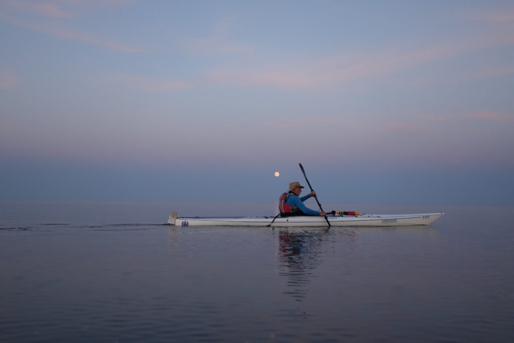
New day, new goals! The sun is shining, the lake is calm. Peaceful paddling southbound.


This day ends up to be the most magical part of this expedition. May full moon – and we are there on the lake to be part of it!!!


We approached the final goal and were just about to round the last island – Trollön.
A thrilling name of an island in full moon. Why is it named Trollön? The rocks were wild and had quartz veins. Very special in the dusk and the full moon light. Suddenly a big opening appeared in the rock. The home of the trolls? After a bit of thinking we found out it was an old place for quartz refraction – and it was possible to paddle inside!


A very special place and occasion to end up a wonderful day of paddling along the coast of Dalsland. We struggled a bit with mosquitoes, but didn’t want to leave the place in the magical night. The last 500 metres passing the lighthouse Vingens fyr into Vingens harbor in moonlight before arriving back to the car is unforgettable. On our way back to the car with the kayaks through the forest, we heard the cat owl howling in the woods and the loon’s sounds out in the lake.


Couldn’t resist to start this day with a photo of the most enormous rhododendron in blossom we have ever seen – at our final starting point by car and paddle destination for this day – Vita Sannar. After weeks of sunny weather, no rain and hot weather we welcomed the clouds, we were hoping for rain. The paddling started where it ended last night. Today we were paddling through the nature reserve Yttre Bodane. The sky was dark blue, grey and very dramatic. Now and then the sun broke through and gave life to the water. Impressive!


Through reeds and past small islands. The production of pine pollen has been enormous this spring. We found it everywhere in calm waters.


Beautiful plants and lichens reinforces the nature experience.


Yttre Bodane is a paddler’s paradise. Shallow waters means that the fairway is very narrow and the area for kayaks is large. Silent paddling. We met a swimming roe deer crossing between islands, observed an old beaver hut. Eventually the rain started. It’s a very special feeling paddling in between islands, hearing and observing the raindrops falling – giving new life to nature. Refreshed by the rain and the paddling today’s passage is done. Back to the car we encounter some friendly cows.


Ready for the last part of this expedition. We started at Köpmannebro – the entrance to Dalslands kanal. Stones and walls on the shore shows the history of trading with big ships in days gone by. In the fairway the painted warnings on the rocks for cays are still there, even if new modern red and green fairway markers show the way for boats.


We leave the nature reserve and get a free open paddling before we arrive to areas with human activity. A colony of gulls and terns live their lives on the islets by the entrance to Sunnanå – a big modern dwelling built just by the lake. After some kilometers we arrive back to Vita Sannar. In the warm evening sunlight the expedition is over for this time. The smooth sand and the lukewarm water tempts us to new adventures!